

The daymark on the island of Pookikari marks the northernmost reach of the National Park and welcomes you to experience the natural beauty of the park (Photo Anssi Riihiaho)
If one would have to give one reason to sail north along the Finnish coast of the Sea of Bothnia, then that would have to be the nature. Fortunately the Finnish government also understood this and formed significant parts of the sensitive archipelago into the Bothnian Sea National Park as recently as in 2011. The National park stretches some 80 nautical miles along the Sea of Bothnia coast, from the Katanpää fortress island – located a little south of the town Uusikaupunki – to the municipality of Merikarvia. The park covers an area of 912 square km of which a mere 15 sqaure km is land, mostly in the form of islands.

View from the island of Munakari (Photo: Aleksi Malinen)
Most of the islands are – by any account – very recent. The park region is raising up to 5-6 mm/year (that’s ¼ inch) due to what is called the land uplift or post-glacial rebound. This means that the islands have not too long ago been sea floor. A low island that currently rises one meter above water level has only been there for about 200 years! This 360° panorama of the Big Räyhä (Iso Räyhä) island that shows an island that has rather recently risen from the sea.

The daymark of Lyökki is surrounded by typical rough landscape (Photo: Anssi Riihiaho)
A lot of stones, gravel and sand was deposited behind the receding ice of the latest ice age. In many places the new islands are formed by the stone and gravel ridges created by the ice age. Really stony patches are often called Devil’s fields (click for 360° panorama) for rather obvious reasons. This also means long and shallow shores requiring boaters to take extra care when approaching an island. Due to it’s recent nature, the archipelago in the Sea of Bothnia has also been less inhabited than other area. Only some of the bigger islands closer to the mainland have been inhabited. You can still find traces of people on the outer islands. The grey hut that can be seen on many islands have been as temporary dwellings by fishermen (click for 360° panorama). Other islands have been used as pastures, mainly for sheep and cows.

The Bladder campion is a typical flower found along the stony beaches (Photo: Aleksi Malinen)
On the shores of stone and gravel, life is harsh for plants. On small islands, heather, flowers and grasses rule close to the shoreline (click for 360° panorama). Autumn storms and winter ice easily overrun the island and keep the vegetation low. Higher up on the shore, bushes and shrubs take over and trees, mainly pine and spruce, (click for 360° panorama) grow on the bigger islands and on the mainland.

A butterfly rests on a Purple loosestrife (Photo: Aleksi Malinen)
Animal life on the islands is not very abundant. The outer islands are veritable birds sancturies (note that landing on many islands is prohibited during the nesting seasons, look for telltale yellow/red signs on the shores). Gulls and terns are common everywhere in Finland and also fill these waters with their calls. The bird featured on the logo for the park, the goosander, can be seen swimming along the shores together with teals and showelers. The further islands are the habitat of the grey seal, the most abundant species of seal in Finland.

The most prominent animals in the archipelago are the birds, here a recent import, the Barnacle goose (Photo: Aleksi Malinen)
On the bigger islands, smaller mammals can be found. Hares, mice and foxes are some of the typical inhabitants. If you are lucky, you can even spot a moose or a out on the islands, they actually do swim and also move across the ice during winter. Animals of prey are rare, but if you are really lucky you could spot one. The only animal that is dangerous is the common European viper, the only poisonous snake in Finland. It likes to sunbathe on warm stones or cliffs. Sturdy shoes is the only precaution that you need for protection, but you would want to use those in the stony terrain in any case.

The shrubs and bushes offer perfect hiding places for small animals such as hares (Photo: Aleksi Malinen)
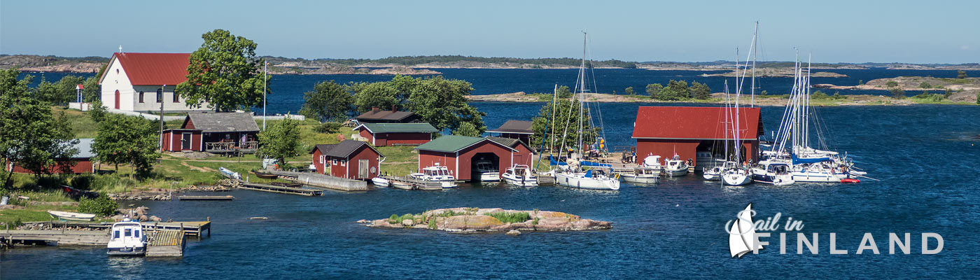
The Bothnian Sea National park is only accessible by boat. If you come on your own boat and want to thoroughly explore the park, a motorboat with a shallow draught and a well protected propeller is your best choice. Sailors will be more restricted as to what islands they can visit because many harbors are quite shallow. Great marinas can be found on the Kylmäpihlaja lighthouse island (click for 360° panorama), Laitakari in the municipality of Luvia (click for 360° panorama) and Reposaari outside Pori.
If you don’t want to visit the on your own boat, there are several companies that offers tours into the park. The park provides information on partner companies operating in the park. You can easily search the list of companies to find the services that you would like to use.

Boaters are welcome in the park, these boaters have moored in the very sheltered Kylmäpihlaja lighthouse harbor (Photo: Aleksi Malinen)
More information and map of the Bothnian Sea National Park
Most of the Bothnian Sea National Park is located in the province Satakunta. The Satakunta website has an excellent information for tourists wanting to visit the National Park, click here for the the Satakunta travel pages. For more information for boaters on the Sea of Bothnia, check this Sail in Finland post.
The map below gives you an overview of the part and what kind of services are available. For full information on the park, check out the ourdoors.fi page on the Bothnian Sea National Park.

Map of the Bothnian Sea National Marks with major sights marked.